Collecting Weather Data
 Image 1 - storm cloud
Using data collected through daily or long term observations and measurements, and patterns in weather can be seen. Weather predictions are based on qualitative (data that can be observed, but not measured) and quantitative (data that can be measured) collected data; they are not just guesses.
- Some weather signs can be seen by looking at clouds.
- Changes in wind speed or wind direction can indicate storms or temperature changes.
 Image 2
Meteorologists interpret information from a variety of sources and use those sources to make predictions. The information they use is shown on a weather map.
- Weather maps may show large masses of warm or cold moving air. Lines between the air masses are called fronts.
- When a warm front passes over an area, the air temperature increases.
- When a cold front passes over an area, the air temperature decreases.
- Data related to temperature and precipitation can also be found on a weather map.
Weather conditions and patterns can be predicted based on weather data collected from various sources.
DIRECT OBSERVATIONS AND MEASUREMENTS
Basic weather conditions can be observed and/or measured using instruments or obtained from meteorologists at national weather data collection sites. In order to make weather predictions, the data should be collected on a regular basis over a period of time. This allows for the development of patterns in weather conditions from the analysis of the data. For example, a hurricane’s path can be predicted using data on its position over time (plotted on a hurricane tracking map), thereby allowing meteorologists to make predictions concerning the possible warnings to land areas in the hurricane’s path.
Basic weather conditions can be observed and/or measured using instruments or obtained from meteorologists at national weather data collection sites. In order to make weather predictions, the data should be collected on a regular basis over a period of time. This allows for the development of patterns in weather conditions from the analysis of the data. For example, a hurricane’s path can be predicted using data on its position over time (plotted on a hurricane tracking map), thereby allowing meteorologists to make predictions concerning the possible warnings to land areas in the hurricane’s path.
|
SATELLITES
Satellite images are used for seeing cloud patterns and movements. For example, hurricane clouds and movement can be observed using satellite images. 
Image 4 - weather conditions from a satellite
|
RADAR
Radar images can be used to detect cloud cover, rainfall or storm location, intensity, and movement, as well as the potential for severe weather (for example, hurricanes or tornadoes). 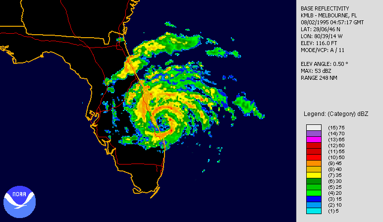
Image 5 - radar shows a storm over Florida
|
 Image 6
WEATHER MAPS
Weather maps can help predict weather patterns by indicating high or low-pressure systems, movement of air masses and fronts, or temperature ranges. Station models from specific locations provide information that can also be used to predict weather patterns. Information found on a station model can include cloud cover, temperature (85°F), wind direction and speed, precipitation (* - snow, ● – rain).
Weather maps can help predict weather patterns by indicating high or low-pressure systems, movement of air masses and fronts, or temperature ranges. Station models from specific locations provide information that can also be used to predict weather patterns. Information found on a station model can include cloud cover, temperature (85°F), wind direction and speed, precipitation (* - snow, ● – rain).
Sources:
Text: ed.sc.gov
Image 1: https://upload.wikimedia.org/wikipedia/commons/9/98/Storm_clouds.jpg
Image 2: http://www.jelmhorst.com/uploads/2/4/6/7/24676165/a61105e315edd0f019bf014dc9fd7611_1.gif
Image 3: http://www.noaanews.noaa.gov/stories2004/images/francestracking090304-5pm.jpg
Image 4: http://maxpixel.freegreatpicture.com/Weather-Satellite-Record-Depression-Cyclone-Iceland-63213
Image 5: https://upload.wikimedia.org/wikipedia/commons/7/70/ErinFloridaLandfallRadar.gif
Image 6: http://www.noaanews.noaa.gov/stories2004/images/weathermap020204.jpg
